This site may earn affiliate commissions from the links on this page. Terms of use.
Researchers have snapped the best-resolution view of the sun ever, courtesy of the Daniel K. Inouye 4-meter solar telescope. The image, which resolves features as small as 18 miles wide (30km), is an unprecedented glimpse of what the surface of the sun really looks like.
Typical images of the sun look like this, as captured by NASA’s Solar Dynamics Observatory (SDO), in geosynchronous orbit above Earth.
This sort of image shows us a certain amount of detail, but it’s missing a lot — partly as a consequence of being shot from 93 million miles away. Then again, the SDO is also in orbit, which we know typically allows for much better viewing conditions than any ground-based telescope.
What allows the Inouye Solar Telescope to see in such detail compared with the SDO? Adaptive optics, location, and sheer size. At four meters (technically 4.24), the Inouye is the largest solar telescope on Earth and its location at Hawaii is one of the best-known locations for clear-sky viewing during the day. The situation appears to be analogous to the relationship between Hubble and some of our largest ground-based telescopes. Hubble has a 2.4-meter lens, while the European Extremely Large Telescope currently under construction in Chile will have a 39.3-meter lens upon completion. Hubble isn’t important because it presents us with the largest window on the heavens, but because the specific characteristics of space-based observation give us an additional level of bit-depth in areas other than the additional light-gathering capability from scaling up a lens. The Inouye Solar Telescope is expected to cooperate on observations with the already in-orbit NASA Parker Solar Probe and the joint ESA/NASA Solar Orbiter (currently prepping for launch).
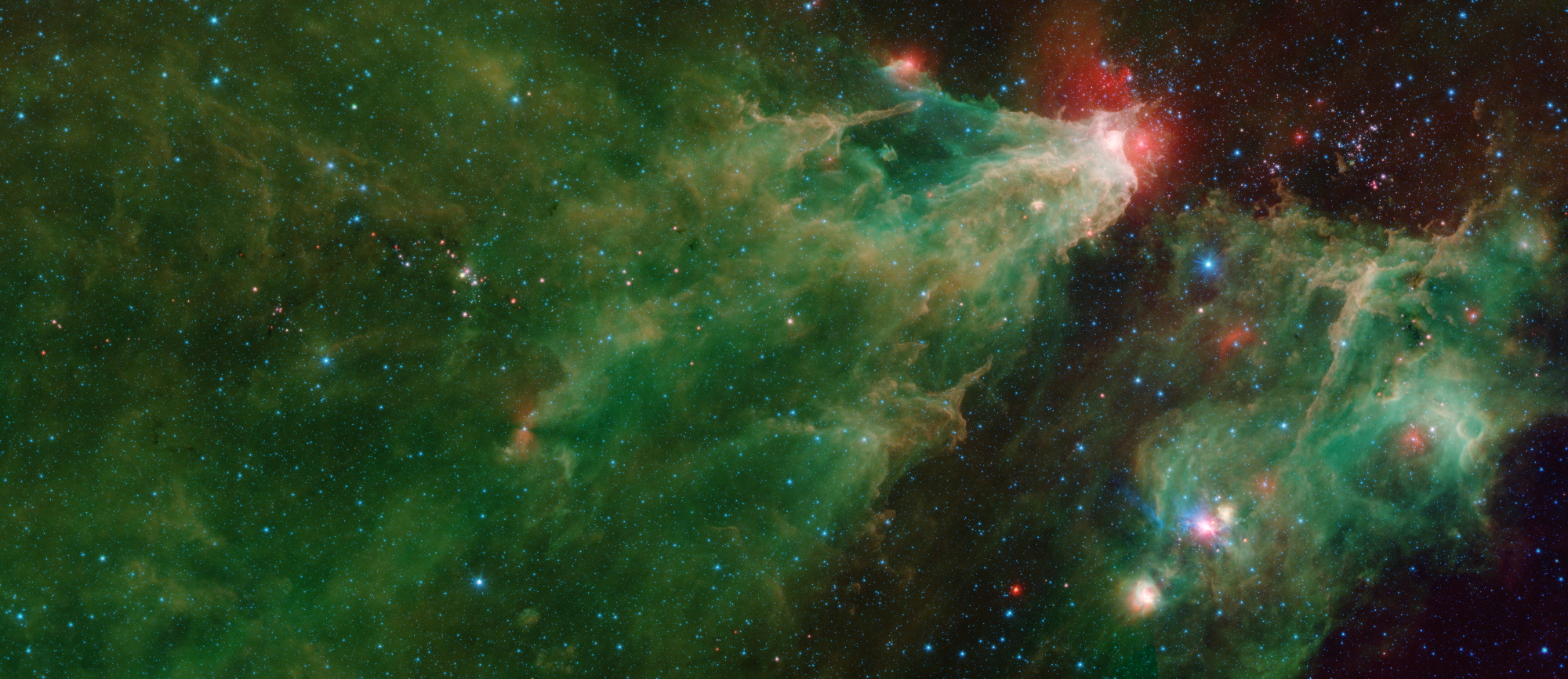
In this case, the 4-meter telescope was able to make out what looks a lot like peanut brittle.
The cell-like structures – each about the size of Texas – are the signature of violent motions that transport heat from the inside of the sun to its surface. Hot solar material (plasma) rises in the bright centers of “cells,” cools off and then sinks below the surface in dark lanes in a process known as convection. In these dark lanes we can also see the tiny, bright markers of magnetic fields. Never before seen to this clarity, these bright specks are thought to channel energy up into the outer layers of the solar atmosphere called the corona. These bright spots may be at the core of why the solar corona is more than a million degrees!
These images have been lightly processed to remove noise and enhance the shape of the structures; the full data set is still undergoing scientific analysis. Still, seeing the fine-scale structure of the sun is a reminder that it isn’t actually “just” a ball of burning gas. The science of how heat is theorized to move through a star and the large-scale structures we observe has implications for stellar theory. It could tell us something about how our own sun is evolving over its own lifespan, and might even have implications for our attempts to create sustainable fusion power generation on Earth. A better understanding of solar dynamics might also enable us to predict coronal mass ejections in the future — and that could be critically important, given the risk they pose.
I’m downright curious to see what kind of new data we’ll learn once the Parker Solar Probe, Solar Orbiter, and the Inouye Solar Telescope are online simultaneously.
The best infrared eye in the universe has closed, and scientists will need to wait at least a year before any similar instrument is at work again.
NASA turned off its Spitzer Space Telescope yesterday (Jan. 30), ending a 16-year mission. The agency at first stretched the observatory's tenure to overlap with that of the next great infrared space telescope, the James Webb Space Telescope. But as that instrument continued to miss schedule targets, with a March 2021 launch currently targeted, NASA eventually concluded that a year's gap in infrared observations of the universe wouldn't harm science.
Spitzer launched in 2003, designed for a 2.5-year mission. But like so many other NASA missions, it far outlived its original directive. Even after it ran out of the coolant needed to keep its most temperature-sensitive instrument working, Spitzer continued to gather valuable scientific data.
But Spitzer's end has been coming since 2016, when NASA conducted a regular review of its missions and decided that it wasn't worth operating the telescope once its successor came online. "The decision was made that the Spitzer mission should end as the James Webb mission was beginning," Paul Hertz, director of the astrophysics division of NASA's Science Mission Directorate, said during a news conference held on Jan. 22.
To that end, NASA extended Spitzer's mission twice more, to keep pace with delays in launching Webb, settling on this week's shutdown after Webb's launch was scheduled for March 2021. "The time has come for the Spitzer mission to end as we move on to the launch of James Webb next year," Hertz said.
The gap between telescopes could still lengthen; on Jan. 28, the Government Accountability Office released an oversight document about the James Webb Space Telescope reporting that the observatory had just a 12% chance of meeting the March 2021 launch target. Because of lost padding time in the project's schedule, a more feasible launch date would fall in July 2021, the agency found.
And once the James Webb Space Telescope does launch, it won't be quite the same. Although both observatories can sense infrared light, they aren't quite interchangeable. Spitzer and Webb are targeted to two different ranges of infrared, with Webb primed to see shorter wavelengths — closer to visible light — than Spitzer did.
Today, after 16 years of exemplary service, NASA will officially deactivate the Spitzer Space Telescope. Operating for over a decade beyond its designed service lifetime, the infrared observatory worked in tandem with the Hubble Space Telescope to reveal previously hidden details of known cosmic objects and helped expand our understanding of the universe. In later years, despite never being designed for the task, it became an invaluable tool in the study of planets outside our own solar system.
While there’s been no cataclysmic failure aboard the spacecraft, currently more than 260 million kilometers away from Earth, the years have certainly taken their toll on Spitzer. The craft’s various technical issues, combined with its ever-increasing distance, has made its continued operation cumbersome. Rather than running it to the point of outright failure, ground controllers have decided to quit while they still have the option to command the vehicle to go into hibernation mode. At its distance from the Earth there’s no danger of it becoming “space junk” in the traditional sense, but a rogue spacecraft transmitting randomly in deep space could become a nuisance for future observations.
From mapping weather patterns on a planet 190 light-years away in the constellation Ursa Major to providing the first images of Saturn’s largest ring, it’s difficult to overstate the breadth of Spitzer’s discoveries. But these accomplishments are all the more impressive when you consider the mission’s storied history, from its tumultuous conception to the unique technical challenges of long-duration spaceflight.
A Scope for the Shuttle
While the Spitzer Space Telescope might have been launched in 2003, its origins date back to the Apollo era. As NASA’s ability to launch large payloads into space improved, astronomers began to consider the possibility of an orbiting infrared observatory. An IR telescope in space would vastly outperform a similarly sized telescope on Earth due to the fact that most of the infrared radiation from space is absorbed by water vapor and carbon dioxide in the atmosphere. While it would be a considerable technical challenge to build, launch, and operate such a telescope, there was no question it would be able to do more useful science than anything that could be built on the ground.
Concept art from the Hughes design study.
In 1976, Hughes Aircraft Corporation released their preliminary design study for the Shuttle Infrared Telescope Facility (SIRTF), a cryogenically cooled IR telescope that would be mounted inside the cargo bay of the Space Shuttle. Thanks to the promised rapid reusability of the Shuttle, the SIRFT could be regularly upgraded and reflown to take advantage of improvements in IR imaging technology.
Unfortunately, the reality of the Space Shuttle program turned out to be very different than what was originally envisioned. Rather than launching regularly and cheaply like a commercial airliner, the Shuttle ended up being just as slow and expensive a ride into space as more traditional rockets. To make matters worse, experiments performed during the STS-51-F mission showed that IR observations made from the Shuttle were complicated by the aura of dust and heat that surrounded the winged orbiter.
By the mid-80s, it became clear SIRTF wasn’t going to work as a part of the Shuttle. It would need to be a free-flying instrument, which naturally made the design considerably more complex. SIRTF would not only have to fit onto a smaller rocket, but it would also need to have its own means of communication, propulsion, navigation, and power generation.
Beating the Heat
Throughout the 1990s, the SIRTF concept went through several revisions. Now called Space Infrared Telescope Facility to differentiate itself from the earlier Shuttle-centric design, the new telescope needed to be small and light enough to be carried on a Delta II rocket. Optimizing a design for spaceflight is never easy, but in the case of the SIRTF, it posed some unique challenges.
For optimal performance, the IR sensors would need to be cooled down to near absolute zero. This means a cryogenic coolant and insulation, which adds mass and bulk to the spacecraft. The easiest way to reduce launch mass would be to load less coolant onboard, but that reduces the useful life of the telescope: an exceptionally difficult compromise to make.
To solve the problem, a radical change was made to the original concept. Rather than operating in low Earth orbit like the Hubble Space Telescope, SIRTF would be launched into deep space. At that distance, the cooling system would no longer have to contend with the heat radiating from the Earth. Naturally the spacecraft would be heated by the sun as well, but that could be mitigated with a passive solar shield. SIRTF would still need to bring along liquid helium to cool the sensors, but in deep space it would require far less.
With these changes to the mission parameters, it was estimated that the SIRTF could keep its instruments cooled to approximately 5 Kelvin ( -268 °C, -450 °F) for up to 5 years.
Spitzer’s Evolving Mission
The SIRTF was launched aboard a Delta II rocket on August 25th, 2003. As was customary at the time, NASA didn’t officially change the spacecraft’s name to the Spitzer Space Telescope until it was ready to begin observations. It was named after Dr. Lyman Spitzer, an early proponent of space telescopes who helped lobby Congress for the funding necessary to build the Hubble before his death in 1997.
From December 2003 to May 2009, Spitzer observed the energy from distant galaxies, young forming stars, and exoplanets at wavelengths between 3.6 μm and 160 μm. After that point the liquid helium ran out, and the temperature of the instrumentation rose to approximately 30 K (−243 °C, −406 °F). This limited the telescope’s observations to a minimum wavelength of 4.5 μm, and marked the beginning what mission controllers referred to as the “Spitzer Warm Mission”.
An image created using data from the “Cold” phase of Spitzer’s mission. Credit: NASA/JPL-Caltech
By the time the so-called warm phase of the mission started, Spitzer was already years beyond its original design lifetime. But the discoveries it made during this period, either on its own or when working in conjunction with other instruments and observatories, were no less impressive. Data from Spitzer helped identify a galaxy that lies an incredible 32 billion light-years from Earth, and techniques such as transit photometry and gravitational microlensing enabled it to perform exoplanet research which had never even been considered in its original mission.
Scientific observations have continued to the present day, though in recent years, declining battery health and the ever-increasing distance between Spitzer and Earth has made downloading the resulting data more difficult.
The Future of Infrared Astronomy
The Spitzer Space Telescope has already outlived the European Space Agency’s similar William Herschel Telescope, and NASA’s Wide-field Infrared Survey Explorer (WISE) isn’t sensitive enough to perform the same sort of observations. Naturally there’s plenty of data to sift through for the time being, but after today, how long will astronomers have to wait before new IR observations can be made?
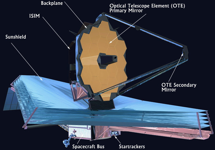
The James Webb Space Telescope
Spitzer’s direct successor, known as SAFIR (Single Aperture Far InfraRed), is at this point just a concept with no firm timeframe for its construction or launch. The European Space Agency is looking to launch Euclid in 2022, though it will only be able to look as far into the infrared wavelengths as Spitzer. NASA also continues to operate Stratospheric Observatory For Infrared Astronomy (SOFIA), a modified Boeing 747 that flies high enough to avoid the majority of the IR-blocking water vapor in the atmosphere.
But certainly the most exciting prospect on the horizon is the James Webb Space Telescope (JWST). Slated to be launched next year, the JWST won’t be able to see all of the same IR wavelengths that Spitzer did during its cold phase, but the telescope’s incredibly large 6.5 meter diameter mirror will allow it to observe objects that are dimmer and farther away than ever before.
Satellite operators, and everyone else who wants a safe and sustainable space environment, dodged a bullet Wednesday evening (Jan. 29).
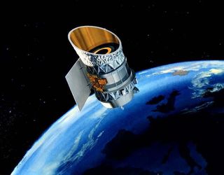
Two defunct satellites — the Infrared Astronomical Satellite (IRAS) and the Gravity Gradient Stabilization Experiment (GGSE-4) — cruised safely past each other high in the skies above Pittsburgh.
The near miss of space junk, which occurred at 6:39 p.m. EST (2339 GMT), was expected; various analyses over the past few days by California-based tracking company LeoLabs had pegged the chance of a collision at just 0.1% to 5%. NASA officials told Space.com that the U.S. military's 18th Space Control Squadron, which tracks space debris and satellites, estimated just a 0.07% chance of a collision. (LeoLabs' final pre-conjunction calculation estimated a close-approach distance of 154 feet, or 47 meters).
"We are pleased to report that in the first several radar passes of the two objects after the close approach, we see no evidence of new debris. This event has served to highlight the collision risks caused by derelict satellites in LEO [low Earth orbit]," LeoLabs representatives said via Twitter on Wednesday night.
We are pleased to report that in the first several radar passes of the two objects after the close approach, we see no evidence of new debris. This event has served to highlight the collision risks caused by derelict satellites in LEO.January 30, 2020
An artist's illustration of the Infrared Astronomical Satellite (IRAS) in Earth orbit. (Image credit: NASA)
But a smashup was possible, and it could have been very bad indeed. The nearly 2,400-lb. (1,090 kilograms) IRAS and the 190-lb. (85 kg) GGSE-4 are both traveling very fast, and a collision would likely have generated hundreds of pieces of debris, said Jonathan McDowell, an astronomer at the Harvard-Smithsonian Center for Astrophysics who keeps tabs on many of the objects circling Earth using publicly available U.S. tracking data.
Most of that debris would have stayed in IRAS' orbit, a sun-synchronous path favored by many weather and spy satellites. And IRAS' neck of the cosmic woods is similar to that once inhabited by a weather satellite that China destroyed during a notorious, oft-criticized 2007 test.
"So, there's already a lot of debris in that orbit," McDowell told Space.com before Wednesday night's close approach. "Adding more would not be good."
There will doubtless be many more close calls in the coming years; space is getting more and more crowded, after all. There are multiple reasons for this, including the decline in the cost of constructing and launching satellites and the building out of internet megaconstellations, such as SpaceX's Starlink network.
So, space junk trackers such as LeoLabs and the U.S. Air Force will be increasingly busy for the foreseeable future.
"There's a whole lot of good economic development, new satellites going into space, but they're faced with a debris problem that already exists," LeoLabs CEO and co-founder Dan Ceperley told Space.com on Wednesday morning. "This is a problem that — we really need to prevent its growth. We can't really clean it up afterwards."
IRAS, a collaboration among NASA, the Netherlands and the United Kingdom, launched in January 1983 and studied the cosmos in infrared light for 10 months. GGSE-4 operated from 1967 through 1972. It was a U.S. National Reconnaissance Office satellite designed to collect signals intelligence, McDowell said. And GGSE-4 was a cover name; the craft's real moniker was POPPY 5B, according to McDowell.
Mike Wall's book about the search for alien life, "Out There" (Grand Central Publishing, 2018; illustrated byKarl Tate), is out now. Follow him on Twitter @michaeldwall. Follow us on Twitter@Spacedotcom orFacebook.
What just happened? Most of us have seen the Sun thousands upon thousands of times throughout our lives, but only from a distance. True, high-definition images of our life-giving star are in short supply, but that makes today's news all the more exciting. Astrologists from the National Science Foundation (NSF) have obtained the first images and video from their high-definition, Sun-studying Inouye Solar Telescope, and the results are fascinating.
The image you see above is the highest resolution image of the Sun's surface that's ever been taken, according to the NSF. And given how amazing it looks, we're willing to take the organization at its word.
What you see in the image is the "boiling gas" that completely covers our solar system's central star. Each small "cell" in the picture is about the size of Texas, and they shift and change as different parts of the Sun's surface "plasma" boil to the surface. When in motion, as you can see below, the effect can look quite beautiful.
The NSF's Solar Telescope is located in Haleakala, Maui, in Hawai'i, and it's about four meters in size. Though its ability to produce excellent-quality images of the Sun is certainly nice for us onlookers, the Telescope's primary goal is a bit more practical in nature.
The NSF hopes to use it to understand the Sun and its effect on our home planet a little better. For example, when "space weather" occurs throughout the star, the magnetic eruptions it emits can interfere with communications on Earth and even cause long-term power blackouts. By studying the Sun's behaviors, forecasters may eventually be able to predict not just Earth-based storms, but solar storms as well, and thus help humans prepare for the events.
We're not sure what other findings the Solar Telescope will turn up over time, but we're certainly looking forward to finding out.
World Health Organization to convene over coronavirus outbreak
The director general of the World Health Organization announced that he would reconvene the International Health Regulations Emergency Committee on Thursday to advise him on whether the deadly coronavirus outbreak constitutes a public health emergency of international concern, or PHEIC. Last week, the committee found it was too soon to make such a declaration. A flight carrying 195 passengers fleeing the source of the outbreak – the Chinese city of Wuhan – landed in California on Wednesday after an emotional stopover in Alaska. All those passengers voluntarily agreed to remain at March Air Reserve Base in Riverside, California, for monitoring, health authorities said. The death toll in China rose to at least 170 on Thursday.
Americans stuck in Wuhan bored, hungry for coronavirus info
Fleeing Wuhan: Coronavirus deaths, infections boom in China
United becomes first US airline to cancel some China flights amid coronavirus
President Trump plans show of GOP strength in Iowa
President Donald Trump will hold a rally in Des Moines, Iowa, Thursday night on the eve of a key vote in the Senate impeachment trial. The Trump campaign sees the event as a show of the president's power over the GOP as Senate Republicans prepare to vote Friday on whether to end his impeachment trial or extend it by hearing from witnesses. The rally is also designed to steal Democrats' thunder as they prepare to select a presidential candidate in the Iowa causes Monday. Trump's campaign plans to follow up his visit by sending an armada of Republican heavyweights to the state.
Iowa power: Do winners of the Iowa caucus typically become president?
Bolton stirs GOP fury for Trump revelations but friends say he's used to knife fights
So long, Spitzer Space Telescope. Thanks for the pictures.
NASA is pulling the plug on one of its most successful missions Thursday: After more than 16 "extraordinary years of exploration," NASA's infrared Spitzer Space Telescope will be "turned off" and put into hibernation in space. NASA credits the telescope with discoveries that include "exoplanets" – planets outside our solar system – and galaxies that formed close to the beginning of the universe. Altogether, Spitzer observed 800,000 celestial targets and churned out more than 36 million raw images as part of its $1.4 billion mission. Taking Spitzer's place will be the new James Webb Space Telescope, expected to launch in 2021.
Pompeo to begin overseas trip amid impeachment trial, controversy
Secretary of State Mike Pompeo is expected to arrive in Ukraine — the country at the center of President Donald Trump's impeachment — on Thursday. Last week, Pompeo unloaded on National Public Radio host Mary Louise Kelly after an interview in which she questioned him on Ukraine and Iran, among other issues. According to NPR, Pompeo used the "F-word" and other expletives— Pompeo responded by calling Kelly a liar and suggesting she was unable to point out Ukraine on an unmarked map. The State Department, which barred an NPR reporter from the trip, said Pompeo is going to Kyiv to "highlight U.S. support for Ukraine’s sovereignty and territorial integrity."
Final episode of NBC's 'The Good Place' to air
It's time to say goodbye to "The Good Place." The show will round its goofy and creative exploration into some of life's most complex questions with a one-hour season finale Thursday at 8:30 EST/PST. For many the show has been a "unique half-hour of American network television." Namely because "The Good Place" has never shied away from making shocking, genre-defying story choices and stayed true to the message that anyone can be good, and nobody is broken beyond repair. The finale will be followed by a Seth Meyers-hosted special featuring the cast and creator Michael Schur.
TechCrunch ist Teil von Verizon Media. Klicken Sie auf 'Ich stimme zu.', um Verizon Media und dessen Partnern Ihre Einwilligung zu geben, Cookies und ähnliche Technik zu nutzen, um auf Ihr Gerät zuzugreifen und Ihre Daten (einschließlich Standort) zu nutzen, um mehr über Ihre Interessen zu erfahren, personalisierte Anzeigen bereitzustellen und deren Effektivität zu messen. Wir stellen außerdem personalisierte Anzeigen für Partnerprodukte bereit.
Weitere Informationen, wie wir Ihre Daten nutzen, finden Sie in unserem Datenschutzcenter. Sie können Ihre Datenschutz Einstellungen künftig in Ihrem Datenschutz-Dashboard ändern.
Klicken Sie auf 'Weitere Informationen', um zu erfahren, wie Verizon Media und dessen Partner Daten erfassen und verwenden, und um dies anzupassen.
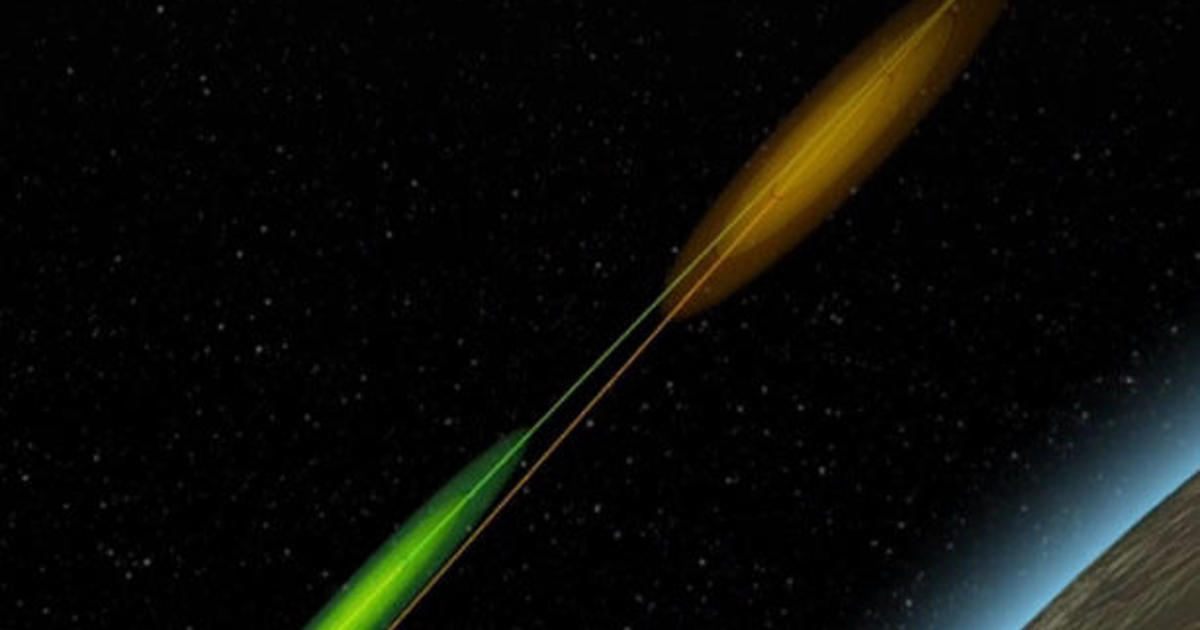
What is hoped to be a near-miss will happen Wednesday evening directly above the city — 900 kilometers high, to be exact.
LeoLabs, which tracks space debris, put out the alert along with a visualization of the event -- and it's going to be very close.
Trending News
LeoLabs predicts that the two satellites will pass within 15 to 30 meters of one another just after 6:30 p.m.
One satellite is roughly the size of a trash can, about 10 pounds. The other is the size of a small car. They're headed straight for each other at more than 10 times the speed of a bullet.
"These are actual spaceships that could collide in space. … They're unmanned and they've been not operational for a while," said Ralph Crewe, who's with the Bulh Planetarium and Observatory of the Carnegie Science Center.
The odds of the two satellite actually colliding are around one-in-100.
According to LeoLabs, one of the two satellites is a decommissioned space telescope that was launched in 1983 and the other is an experimental U.S. payload that was launched in 1967.
Crewe brought CBS Pittsburgh's cameras up to the roof at the Carnegie Science Center to talk about what this means for Pittsburghers on the ground.
"It's not guaranteed that it's going to collide, but if it does, any fragments that fall to Earth are going to hit the atmosphere at tremendous speed and burn up, much like a shooting star," he says. "In fact, if you do see anything, it will look sort of like a burst of shooting stars almost."
There's no need to panic. If these satellites do collide, we're not in any trouble.
"Thankfully, it is relatively safe. Nobody on Earth has any chance of taking any damage from this, so it will just be an amazing show in the sky," said Crewe.
Let's hope that today's close encounter of two old pieces of space junk is just a near miss as predicted, because a smashup would be pretty messy.
Two long-dead satellites — the Infrared Astronomical Satellite (IRAS) and the Gravity Gradient Stabilization Experiment (GGSE-4) — will whiz past each other this evening (Jan. 29) about 560 miles (900 kilometers) above Pittsburgh, Pennsylvania.
At closest approach, which occurs at 6:39 p.m. EST (2339 GMT), the two defunct craft will be just 43 feet to 285 feet (13 to 87 meters) apart, according to the latest calculations by California-based satellite-tracking company LeoLabs.
Our latest data on the IRAS / GGSE 4 event shows potential miss distances of 13-87 meters, with a lowered collision probability currently at 1 in 1000. Time of closest approach remains at 2020-01-29 23:39:35.707 UTCJanuary 28, 2020
Those calculations also peg the probability of a collision between IRAS and GGSE-4 at just 0.1%. ThE low odds are a very good thing, considering that both hunks of metal are traveling at more than 32,000 mph (51,500 km/h).
If the collision happens, "I would expect it to be comparable to, but maybe not quite as bad as, the Iridium-Kosmos collision in 2009," said Jonathan McDowell, an astronomer at the Harvard-Smithsonian Center for Astrophysics who monitors many of the objects circling Earth using publicly available U.S. tracking data.
That February 2009 crash, which involved the operational Iridium 33 communications satellite and the defunct Kosmos-2251 Russian military craft, spawned 1,800 pieces of trackable debris by the following October, as well as many other shards too small to detect from the ground. It's perhaps the most famous space-junk event in history, rivaled only by a notorious 2007 Chinese anti-satellite test and a similar Indian demonstration last year.
"So you would see, maybe not thousands of pieces of trackable debris, but at least hundreds," McDowell told Space.com.
The The Infrared Astronomical Satellite (IRAS) orbits the Earth in this illustration. (Image credit: NASA)
GGSE-4 weighs about 190 lbs. (85 kilograms) — much less than IRAS, which tips the scales at nearly 2,400 lbs. (1,090 kg). (Reports that GGSE-4 weighs just 10 lbs., or 4.5 kg, are based on a mistaken assumption that GGSE-4 is similar to GGSE-1, which was a much simpler satellite, McDowell said.)
Most of the debris spawned by a collision between IRAS and GGSE-4 would likely stay in the more massive satellite's path — a sun-synchronous orbit (SSO), which takes a spacecraft over a planet's poles.
"And that's unfortunate, because sun-synchronous orbit is where everyone wants to be," McDowell said. "So, there's a bunch of satellites in that altitude range and orbit."
These include many weather and spy satellites, which take advantage of the consistent lighting. (Spacecraft in an SSO pass over a given patch of Earth at the same local solar time each day, meaning that illumination conditions are consistent across observations.)
IRAS' orbit is similar to the Chinese weather satellite that was destroyed in the 2007 test, McDowell added.
"So, there's already a lot of debris in that orbit," he said. "Adding more would not be good."
Even tiny pieces of debris can be satellite killers, given how fast objects move in Earth orbit. So, a few collisions in a heavily trafficked patch of space could theoretically lead to a catastrophic cascade of smashups that significantly reduces access to, and exploitation of, the final frontier — a nightmare scenario known as the Kessler syndrome.
It's not uncommon for chunks of debris to give satellites a close shave. But it is quite rare for two satellites to whiz so close together, said McDowell, who estimated that such events occur once every two years or so.
But these close calls will occur more often in the future as Earth orbit gets more and more crowded. This crowding is occurring because it's getting cheaper and easier to build and launch spacecraft, and also because a few companies are starting to assemble internet-satellite megaconstellations.
For example, SpaceX has permission to launch 12,000 satellites to low-Earth orbit for its Starlink broadband network and has filed paperwork for up to 30,000 more craft. To put this into perspective: About 2,000 operational satellites currently circle Earth, and humanity has lofted a mere 9,000 or so since the dawn of the space age in 1957. And SpaceX's plans are not just hypothetical; Elon Musk's company has already launched several 60-satellite Starlink batches.
Active Starlink craft are a far cry from inert derelict satellites, of course; SpaceX's satellites will be able to sense and autonomously maneuver away from potential collisions, Musk has said. (This didn't happen when a Starlink satellite neared Europe's Aeolus Earth-observation satellite last September; Aeolus performed the evasive action. A paging-system bug prevented Starlink operators from learning that the collision probability had increased enough to warrant a maneuver, SpaceX representatives later said.)
But keeping space open and safe for everyone in such a crowded environment will require some planning and some action, McDowell stressed.
"If we're going to allow this large number of satellites, then we have to require more investment in the tracking and the sort of traffic control of them," he said.
The U.S. Air Force has long done the lion's share of this work. But help is now coming from the commercial sector, as LeoLabs' efforts show. And the company, which was founded in 2016, is poised to make even bigger contributions in the near future; in October, LeoLabs unveiled a new radar system in New Zealand that's designed to track about 250,000 orbiting objects as small as 0.8 inches (2 centimeters) wide.
To repeat: there probably won't be a collision this evening in the skies over Pittsburgh. And even if the two satellites do slam into each other, folks on the ground won't see much, said David Turnshek, a professor of physics and astronomy at the University of Pittsburgh and director of the school's Allegheny Observatory.
IRAS is a fifth- or sixth-magnitude object, meaning it's visible to the naked eye under clear, dark skies. Light-polluted Pittsburgh doesn't qualify, though people there can see the satellite with binoculars when the weather cooperates, Turnshek said.
GGSE-4, on the other hand, is completely beyond the reach of skywatchers.
"That thing is invisible," Turnshek told Space.com. "It's too small."
There will be no dramatic fireball in the sky this evening if a collision does occur. The most striking effect that astronomers could see is likely a slight perturbation in the streak of light that traces IRAS' orbit, Turnshek said.
And he and his colleagues may indeed look for that perturbation with a scope at the Allegheny Observatory.
"We would just point it straight up with no tracking, and have the shutter on our camera open for the few minutes right when the collision is supposed to happen," Turnshek said. "I think it would be fun."
IRAS, by the way, was a joint mission involving NASA, the Netherlands and the United Kingdom. The satellite launched in January 1983 to study the cosmos in infrared light and ceased observations 10 months later.
GGSE-4 launched in 1967. And that was a cover name; the satellite's real moniker was POPPY-5B, and it was a U.S. National Reconnaissance Office craft devoted to collecting signals intelligence, McDowell said.
Mike Wall's book about the search for alien life, "Out There" (Grand Central Publishing, 2018; illustrated byKarl Tate), is out now. Follow him on Twitter @michaeldwall. Follow us on Twitter@Spacedotcom orFacebook.
Last March I wrote about Starlink, SpaceX’s next-generation satellite network.
CEO Elon Musk, who also heads electric-car maker Tesla
TSLA, +1.59%,
expects Starlink to be capable of connecting the globe and offering reliable and affordable broadband internet service via thousands of low-orbit satellites working in combination with ground transceivers.
On Jan. 7, SpaceX launched 60 satellites from Cape Canaveral Air Force Station in Florida, bringing the total to 240. Ultimately the number of Starlink satellites is expected to increase to 12,000 by the mid-2020s, as the plan is to launch one batch every two weeks.
After deployment, over the course of one to four months, these newly launched satellites will use their onboard thrusters to climb from an altitude of 180 miles to 340 miles.
During this phase of flight, the satellites will be closely clustered, with their solar arrays in a low-drag configuration, which will make them more visible from the ground. They will be monitored for malfunctions, and those not performing up to specifications will remain in 180-mile-high orbit, from which they will eventually fall through the atmosphere and burn up.
Challenges ahead
Even though the operation is moving ahead smoothly, there are significant problems that need to be resolved.
Critics are focusing on two main ones.
First, there’s the space junk problem. The first batch of SpaceX’s Starlink satellites had at least 5% “dead” or unresponsive units that were expected by the company to deorbit naturally and burn up in the atmosphere. Once thousands of these satellites rise to a higher orbit, it’s reasonable to assume that a number of them will malfunction. At that point, the descent will take significantly longer (five years at 340 miles altitude and even longer at higher altitudes), and until they come down, they will be a threat to other satellites and space installations.
Even though SpaceX says the satellites have an automated collision-avoidance system, there’s a high chance it won’t function at all in a number of “dead” satellites, turning them into passive pieces of debris capable of knocking out other satellites and endangering space station crew members.
Once SpaceX launches thousands of satellites, hundreds of faulty ones have the potential to get caught up in cascading satellite collisions, wreaking havoc on global communication and navigation.
Second, there’s the potential for Starlink satellites to obstruct observational astronomy. Since they shine brightly in the night sky, reflecting light to various lenses and cameras, they could make ground-based astronomy impossible once tens of thousands of them are launched.
SpaceX is already working on this with an experimental darkening treatment that will be applied to one test satellite to see if the glare of its body can be reduced. If successful, the coating will be applied to upcoming satellite batches as well. SpaceX will also provide leading astronomy groups with data on satellite positions, so astronomers can better coordinate their observations.
Rival companies
These problems are far from easy to solve and should be addressed sooner rather than later. Other companies, including as Amazon.com
AMZN, +1.36%,
OneWeb and TeleSat, plan to launch their own satellites. In the next few years, the number of satellites orbiting Earth could reach 46,000 — that’s more than five times the number of objects that were sent to space in the past 60 years.
As long as they burn out in the atmosphere when they malfunction, steer clear from collisions with other space objects and don’t obstruct astronomical observations, they are a welcome addition to making a global online community even more inclusive.
Do you agree? Please let me know in the comment section below.
The hottest exoplanet's atmosphere is melting before our eyes Livescience.com
https://news.google.com/__i/rss/rd/articles/CBMiRWh0dHBzOi8vd3d3LmxpdmVzY2llbmNlLmNvbS9ob3R0ZXN0LWV4b3BsYW5ldC1tZWx0aW5nLWF0bW9zcGhlcmUuaHRtbNIBSWh0dHBzOi8vd3d3LmxpdmVzY2llbmNlLmNvbS9hbXAvaG90dGVzdC1leG9wbGFuZXQtbWVsdGluZy1hdG1vc3BoZXJlLmh0bWw?oc=5
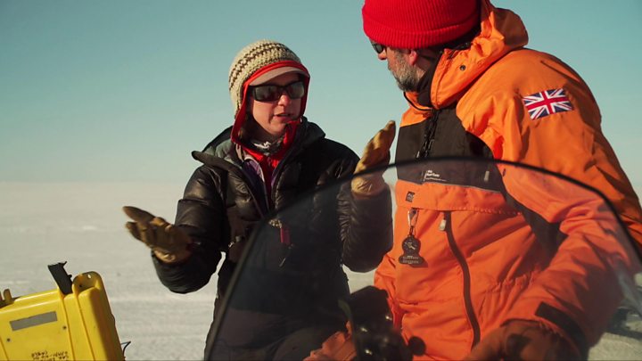
Sediment sweeps past the camera as Icefin, a bright yellow remotely operated robot submarine, moves tentatively forward under the ice.
Then the waters begin to clear.
Icefin is under almost half a mile (600m) of ice, at the front of one the fastest-changing large glaciers in the world.
Suddenly a shadow looms above, an overhanging cliff of dirt-encrusted ice.
It doesn't look like much, but this is a unique image - the first ever pictures from a frontier that is changing our world.
Icefin has reached the point at which the warm ocean water meets the wall of ice at the front of the mighty Thwaites glacier - the point where this vast body of ice begins to melt.
The 'doomsday' glacier
Glaciologists have described Thwaites as the "most important" glacier in the world, the "riskiest" glacier, even the "doomsday" glacier.
It is massive - roughly the size of Britain.
It already accounts for 4% of world sea level rise - a huge figure for a single glacier - and satellite data show that it is melting increasingly rapidly.
There is enough water locked up in it to raise world sea level by more than half a metre.
And Thwaites sits like a keystone right in the centre of the West Antarctic Ice Sheet - a vast basin of ice that contains more than 3m of additional potential sea level rise.
Yet, until this year, no-one has attempted a large-scale scientific survey on the glacier.
The Icefin team, along with 40 or so other scientists, are part of the International Thwaites Glacier Collaboration, a five-year, $50m (£38m) joint UK-US effort to understand why it is changing so rapidly.
The project represents the biggest and most complex scientific field programme in Antarctic history.
You may be surprised that so little is known about such an important glacier - I certainly was when I was invited to cover the work of the team.
I quickly discover why as I try to get there myself.
Snow on the ice runway delays my flight from New Zealand to McMurdo, the main US research station in Antarctica.
This is the first of a whole catalogue of delays and disruptions.
It takes the science teams weeks just to get to their field camps.
At one stage, the entire season's research is on the point of being cancelled because storms stop all flights to West Antarctica from McMurdo for 17 consecutive days.
Why is Thwaites important?
West Antarctica is the stormiest part of the world's stormiest continent.
And Thwaites is remote even by Antarctic standards, more than 1,000 miles (1,600km) from the nearest research station.
Only four people have ever been on the front of the glacier before and they were the advance party for this year's work.
But understanding what is happening here is essential for scientists to be able to predict future sea level rise accurately.
The ice in Antarctica holds 90% of the world's fresh water, and 80% of that ice is in the eastern part of the continent.
The ice in East Antarctica is thick - more than a mile thick on average - but it rests on high ground and only creeps sluggishly to the sea.
Some of it has been around for millions of years.
Western Antarctica, however, is very different. It is smaller but still huge, and is much more vulnerable to change.
Unlike the east it doesn't rest on high ground. In fact, virtually the whole bed is way below sea level. If it weren't for the ice, it would be deep ocean with a few islands.
I've been in Antarctica five weeks before I finally board the red British Antarctic Survey Twin Otter that takes me to the front of the glacier.
I will be camping with the team at what is known as the grounding zone.
They are camped on the ice above the point where the glacier meets the ocean water, and have the most ambitious task of all.
They want to drill down through almost half a mile of ice right at the point where the glacier goes afloat.
No-one has ever done that on a glacier this big and dynamic.
They will use the hole to get access to the sea water that is melting the glacier to find out where it is from and why it is attacking the glacier so vigorously.
They do not have long.
All the delays mean there are just a few weeks of the Antarctic summer left before the weather starts to get really bad.
As the members of the drilling team set up their equipment, I help out with a seismic survey of the bed beneath the glacier.
Dr Kiya Riverman, a glaciologist at the University of Oregon, drills down with an ice auger - a large spiral stainless-steel drill bit - and sets small explosive charges.
The rest of us dig holes in the ice for the "georods" and "geophones" - the electronic ears that listen to the echo of the blast that bounces back from the bedrock through the layers of water and ice.
Thwaites is sitting on the seabed
The reason the scientists are so worried about Thwaites is because of that downward sloping submarine bed.
It means the glacier gets thicker and thicker as you go inland.
At its deepest point, the base of the glacier is more than a mile below sea level and there is another mile of ice on top of that.
What appears to be happening is that deep warm ocean water is flowing to the coast and down to the ice front, melting the glacier.
As the glacier retreats back, yet more ice is exposed.
It is a bit like cutting slices from the sharp end of a wedge of cheese.
The surface area of each one gets bigger and bigger - providing ever more ice for the water to melt.
And that is not the only effect.
Gravity means ice wants to be flat. As the front of the glacier melts, the weight of the vast reservoir of ice behind it pushes forward.
It wants to "smoosh out," explains Dr Riverman. The higher the ice cliff, she says, the more "smooshing" the glacier wants to do.
So, the more the glacier melts, the more quickly the ice in it is likely to flow.
"The fear is these processes will just accelerate," she says. "It is a feedback loop, a vicious cycle."
Doing science of this scale in such an extreme environment is not just about flying a few scientists to a remote location.
They need tonnes of specialist equipment and tens of thousands of litres of fuel, as well as tents and other camping supplies and food.
I camped on the ice for a month, some of the scientists will be out there for far longer, two months or more.
It took more than a dozen flights by the US Antarctic programme's fleet of huge ski-equipped Hercules cargo planes just to get the scientists and some of their cargo to the project's main staging post in the middle of the West Antarctic Ice Sheet.
Then smaller planes - an elderly Dakota and a couple of Twin Otters - ferried the people and supplies on to the field camps, hundreds of miles down the glacier towards the sea.
The distances are so great they needed to set up another camp halfway down the glacier so the planes could refuel.
The British Antarctic Survey's contribution was an epic overland journey that brought in hundreds of tonnes of fuel and cargo.
Two ice-hardened ships docked alongside an ice cliff at the foot of the Antarctic Peninsula during the last Antarctic summer.
A team of drivers in specialist snow vehicles then dragged it more than a thousand miles across the ice sheet through some of the most inhospitable terrain and weather on earth.
It was tough going, the top speed was just 10mph.
Drilling through the ice
The scientists at the grounding zone camp plan to use hot water to drill their hole through the ice.
They need 10,000 litres of water, which means melting 10 tonnes of snow.
Everyone sets to work with spades, hefting snow into the "flubber" - a rubber container the size of a small swimming pool.
"It'll be the most southerly jacuzzi in the world," jokes Paul Anker, a British Antarctic Survey drilling engineer.
The principle is simple - you heat the water with a bank of boilers to just below boiling point and then spray it onto the ice, melting your way down.
But drilling a 30cm hole through almost half a mile of ice at the front of the most remote glacier in the world is not easy.
The ice is about -25C (-13F) so the hole is liable to freeze over and the whole process is dependent on the vagaries of the weather.
By early January, the flubber is full and all the equipment is ready but then we get a warning that yet another storm is on its way.
Antarctic storms can be very intense. It is not unusual to have hurricane force winds as well as very low temperatures.
This one is relatively mild for Antarctica but still involves three days of wind gusting up to 50mph. It blows huge drifts of snow into the camp, swamping the equipment, and all the work stops.
We sit in the mess tent playing cards and drinking tea and the scientists discuss why the glacier is retreating so rapidly.
They say what is happening here is down to the complex interplay of climate, weather and ocean currents.
The key is the warm seawater, which originates on the other side of the world.
As the Gulf Stream cools between Greenland and Iceland, the water sinks.
This water is salty, which makes it relatively heavy, but is still a degree or two above freezing.
This heavy salty water is carried by a deep ocean current called the Atlantic conveyor all the way down to the south Atlantic.
Shifting winds
Here it becomes part of the Antarctic Circumpolar Current, flowing deep - a third of a mile (530m) - below a layer of much colder water.
The surface water in Antarctica is very cold, just above -2C degrees, the freezing point of salt water.
The deep warm circumpolar water travels all the way around the continent but has been increasingly encroaching on the icy edge of West Antarctica.
This is where our changing climate comes in.
The scientists say the Pacific Ocean is warming up and that is shifting wind patterns off the coast of West Antarctica, allowing the warm deep water to well up over the continental shelf.
"The deep Antarctic circumpolar water is only a handful of degrees warmer than the water above it - a degree or two above 0C - but that's warm enough to light this glacier up," says David Holland, an oceanographer with New York University and one of the lead scientists at the grounding zone camp.
I was supposed to leave Antarctica at the end of December but all the delays mean the drilling only begins on 7 January.
That is when the satellite phone call comes from the United States Antarctic Program HQ in McMurdo.
We are told we cannot delay our flights off the continent any longer and must leave on the supply plane that is due to arrive at the camp in an hour or so.
It is very frustrating to be forced to leave before the hole is finished and the instruments have been deployed, especially given how long it took to get here.
We say our goodbyes and board the plane.
I look back and see the wheel at the top of the drill turning, the black hose spooling out steadily.
They are almost half way down through the ice.
The plane flies up over the camp and directly north, out towards the ocean.
The scientists had told me that we had been camped on what is basically a small bay of ice protected by a horseshoe of raised ground.
As we fly out over the front of the glacier, I realise with a shock just how fragile a fingerhold it is.
There is no mistaking the epic forces at work here, slowly tearing, ripping and shattering the ice.
In some places the great sheet of ice has broken up completely, collapsing into a jumble of massive icebergs which float in drunken chaos.
Elsewhere, there are cliffs of ice, some of which rise up almost a mile from the sea bed.
The front of the glacier is almost 100 miles wide (160km) and is collapsing into the sea at up to two miles (3km) a year.
The scale is staggering and explains why Thwaites is already such an important component of world sea level rise, but I am shocked to discover there is another process that could accelerate its retreat even more.
Media playback is unsupported on your device
Melt rates are increasing
Most glaciers that flow into the sea have what is known as an "ice pump".
Sea water is salty and dense which makes it heavy. Melt water is fresh and therefore relatively light.
As the glacier melts, the fresh water therefore tends to flow upwards, drawing up the heavier warmer sea water behind it.
When the sea water is cold, this process is very slow, the ice pump usually just melts a few dozen centimetres a year - easily balanced by the new ice created by falling snow.
But warm water transforms the process, according to the scientists.
Evidence from other glaciers shows that if you increase the amount of warm water that is reaching the glacier the ice pump works much faster.
"It can set glaciers on fire," says Prof Holland, "increasing melt rates by as much as a hundred-fold."
The small plane takes us to the camp in the middle of the West Antarctic Ice Sheet but more bad weather means more delays and it is nine days before a Hercules comes to take us back to McMurdo.
By then we have been joined by some of the scientists.
It has been a very successful season.
They have confirmed that the deep circumpolar warm water is getting under the glacier and have collected huge amounts of data.
Icefin, the robot submarine, has managed to make five missions, taking a host of measurements in the water beneath the glacier and recording some extraordinary images.
It will take years to process all the information the team has gathered and incorporate the findings into the models that are used to project future sea level rise.
Rising sea levels
Thwaites is not going to vanish overnight - the scientists say it will take decades, possibly more than a century.
But that should not make us complacent.
A metre of sea level rise may not sound much, particularly when you consider that in some places the tide can rise and fall by three or four metres every day.
But sea level has a huge effect on the severity of storm surges, says Prof David Vaughan, the director of science at the British Antarctic Survey.
Take London.
An increase in sea level of 50cm would mean the storm that used to come every thousand years will now come every 100 years.
If you increase that to a metre then that millennial storm is likely to come once a decade.
"When you think about it, we shouldn't be surprised by any of this," says Prof Vaughan as we are preparing to board the plane that will take us back to New Zealand and then home.
Ever-increasing carbon dioxide levels are putting a lot more heat into the atmosphere and the oceans.
Heat is energy, and energy drives the weather and ocean currents.
Increase the amount of energy in the system, he says, and inevitably big global processes are going to change.
"They already have in the Arctic," says Prof Vaughan with a sigh. "What we are seeing here in the Antarctic is just another huge system responding in its own way."
The private spaceflight company SpaceX will launch 60 new Starlink satellites to join its growing broadband internet megaconstellation in orbit today (Jan. 27), and you can watch it live online.
A SpaceX Falcon 9 rocket will launch the Starlink mission from Space Launch Complex 40 at Cape Canaveral Air Force Station in Florida. Liftoff is scheduled for no earlier than 9:49 a.m. EST (1449 GMT).
If SpaceX is unable to launch the Starlink-3 mission today, the company has a backup launch opportunity on Tuesday, Jan. 28, at 9:28 a.m. EST (1428 GMT). That launch day has an 80% chance of good weather.
The goal of SpaceX's Starlink project is to provide constant, high-speed internet access to users around the world through a massive constellation of broadband internet satellites operating in low Earth orbit. Users on the ground would then only need a small terminal that's no bigger than a laptop to gain internet access.
"Starlink will provide fast, reliable internet to locations where access has been unreliable, expensive, or completely unavailable," the company wrote in its Starlink mission description.
The majority of SpaceX's missions in 2020 will consist of Starlink launches as the company works to expand its fleet of internet-beaming satellites, including at least one more batch of 60 Starlink satellites scheduled to launch before the end of January. SpaceX CEO and founder Elon Musk has said the company will need at least 400 Starlink satellites in orbit to offer "minor" broadband coverage, and at least 800 to provide "moderate" coverage.
SpaceX plans to operate its initial batch of 1,584 satellites 341 miles (549 kilometers) above Earth, hovering much lower than traditional communications satellites that operate out of geostationary orbit. Those satellites are too far away to provide the kind of lower-cost coverage SpaceX aims to establish, Musk has said.
According to the company, Starlink commercial internet services could debut in parts of the U.S. and Canada after about half a dozen more launches, with global coverage after 24 launches. SpaceX's president and chief operating officer Gwynne Shotwell has said that coverage could begin sometime this year, but the company has not yet announced pricing for its new service.
However, not everyone is thrilled about the idea of SpaceX's new megaconstellation. Astronomers have voiced concerns that the satellites could interfere with crucial scientific observations. To help ease their concerns and mitigate the satellites' apparent brightness, SpaceX is experimenting with special coatings that are supposed to make the satellites appear darker in orbit.
During today's launch, SpaceX aims to recover the Falcon 9's first-stage booster with an offshore landing on its drone ship Of Course I Still Love You.